

Alt-text OP inexplicably refused to give us:
Running for office in Minnesota on the single-issue platform ‘dig a permanent channel through the Traverse Gap because it will make this map more satisfying.’
I deserve this, even promised to remember last time
I will await you’re return with an upvote in hand
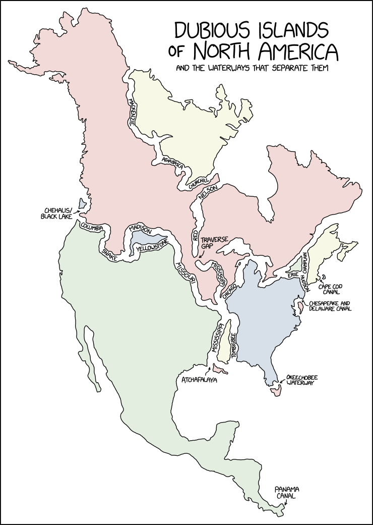
Fun fact, that traverse gap separates the red river of the north from the MINNESOTA river - which eventually drains into the Mississippi. The Mississippi starts at Lake Itasca.
Fun fact #2, the Minnesota/Mississippi drains into the Atlantic via the Gulf, but the red river eventually drains into the Arctic Ocean via the Hudson Bay!
Another fun fact; the Red River is very prone to spring flooding because it flows such a great distance north. The headwaters thaw out and start flowing while the river’s outlet is still frozen over. Many cities and towns in Manitoba have dikes around them and turn into islands during the spring flood. Winnipeg has a flood diversion canal to guide the floodwaters past it each spring.
I think I just ran out of fun facts about Manitoba.
Funny, I thought the Red River drained into Fargo.
I wonder if they were connected, hypothetically, if the Hudson would drain into the Caribbean or the other way around. The North American plains bisect the entire continent so it’s feasible; I just don’t know if the two bodies of water are at the same elevation, and due to gravitational effects, etc, large bodies of water aren’t always at sea level.
As a Newfoundlander, I’ve never felt more insulted.
Yeah, I’m wounded by the
commissionomission of Cape Breton. But I think it’s just that there’s nothing dubious about our islands.Edit: Sausage fingers and rogue autocorrect.
Yeah seen that first and then realized PEI was missing too. Dubious free Islands.
Ahhh, true true
As a Florida-born Texan of partial Newfoundlander heritage, I’m… sort of nonplussed?
Agree with the other poster though. Nothing dubious about Newfoundland’s island status.
I’d be more concerned if, as a Newfie, you were plussed to begin with!
Actually I have no idea what that would mean.
So what I’m hearing is that Lewis and Clark were idiots and you totally can go from coast to coast in a canoe
Chehalis-Blacklake is pretty dubious. It’s a long stretch of wetlands. There is a sign and everything and technically it counts but there’s development and roads going through it without bridges.
Don’t worry, give it 50 years and the waters will rise enough to make it navigable
Which one inherits the name Turtle Island?
XKCD is usually more astute. The lack of the Colorado River, and The Grand Canyon, is a glaring omission.
“XKCD is usually more astute. The lack of the Colorado River, and The Grand Canyon, is a glaring omission.”
Does the Colorado cut off a land mass? I don’t think the Colorado even reaches the sea anymore, let alone psuesocleave apart a part of the continent.
That was a fun last sentence to say.
What could possibly cleave the continent more than the Grand Canyon? In many places it’s a barrier that can’t be crossed except by flight.
It’s a prominent river until Yuma, AZ, which is not too far from the Gulf of California. And even if the water doesn’t always flow, it forms the boundary between the Mexican states of Baja and Sonora.
Yes, but you fail to understand the difference between a peninsula and a psuedo-island (a piece of land entirely surrounded by any body of water, artificial or manmade).
The Colorado River starts in Colorado is does not flow over the continental divide.
No river can be traced all the way up to a dividing ridge. As the contributing drainage area gets smaller it will be a stream, then creek, trickle, gulley, and by the time it’s on a mountain ridge it’s nothing.
You would think so, but there is one river that happens to flow and split over the continental divide called North Two Ocean Creek. It’s the tiniest technicality that makes this map technically true.
We supply you guys with OUR lake water. Don’t forget that
Or else what 😠
Who is our in this case


